
See & do / Hiking and trekking
Welcome to the Natural and Culturo-Historical Region of Kotor
The Natural and Culturo-Historical region of Kotor, part of the Bay of Kotor, is one of over 1000 sites from around the world that is on the UNESCO World Heritage List of places with outstanding value to humanity
![]()
![]() Author: Expeditio
Author: Expeditio
The harmonious relationship between the impressive nature of the bay and diverse and rich cultural heritage, which has been shaped and maintained over centuries, gives the area of Kotor the characteristics of a cultural landscape with outstanding universal value.
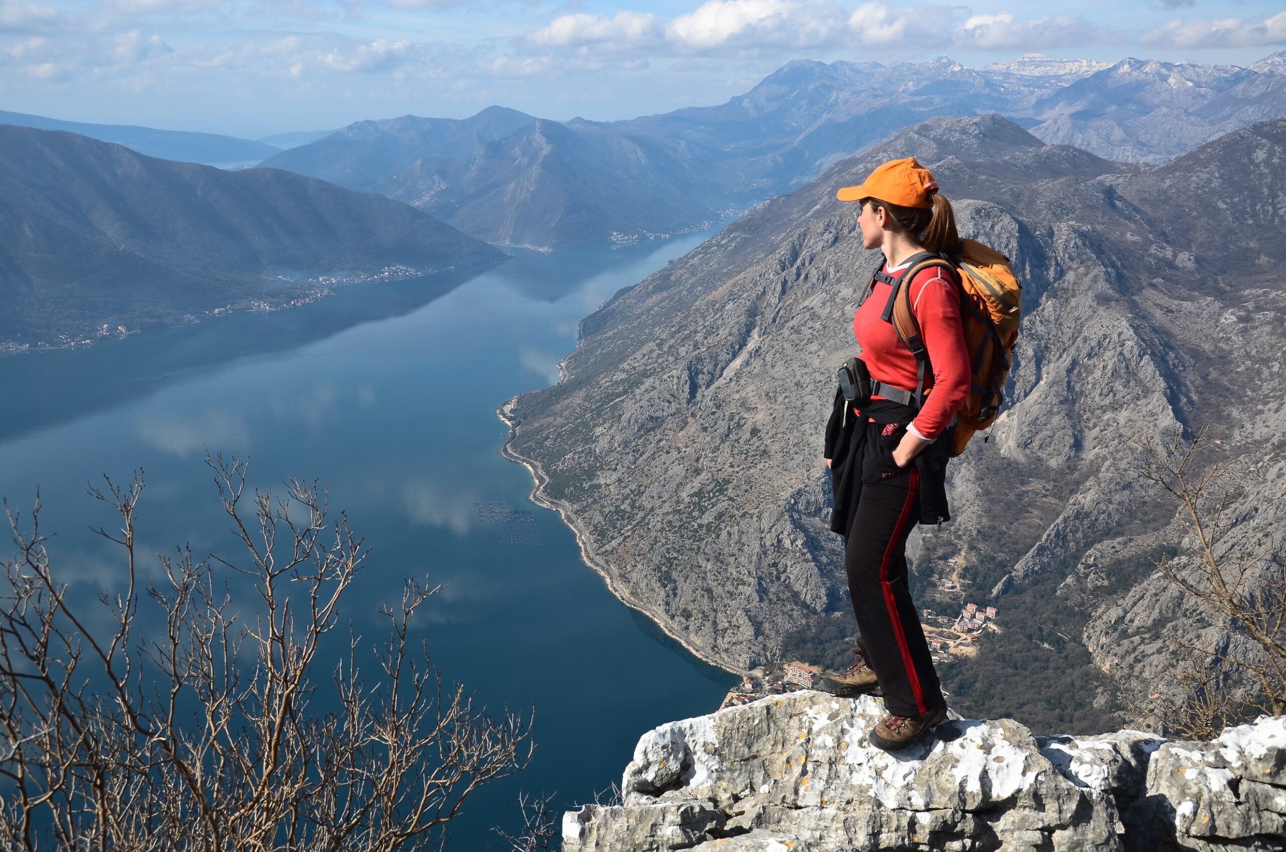
The Bay of Kotor is surrounded on the east side by the slopes of mount Lovćen. The highest peak of Lovćen is Štirovnik (1,749 m above sea level). On Jezerski vrh at 1657 m above seal level there is the Mausoleum of Peter II Petrović Njegoš.
On the west side, Boka is surrounded by Orjen. Between Kotor and Tivat there is the mount Vrmac, with its special natural and cultural values.
In the bay, formed by steep slopes of mountains, with a narrow belt of arable land and a coast of complex shape, cities and settlements were developed in rows during long historical period, separated from each other by land or rocky landscape. In the area of World Heritage are the cities of Kotor, Risan and Perast, and settlements along the coast: Dobrota, Ljuta, Orahovac, Strp, Lipci, Morinj, Kostanjica, Donji Stoliv, Prcanj, Muo.
In the higher zones, at the point where the belt of arable land turns into the steep, rocky or forested slopes of the hill, there are older urban
layers, or upper villages, today mostly abandoned, such as Gornji Stoliv, upper section of Prčanj, upper Kostanjica, Gornji Morinj and Glogovac.
In the hinterland, in the mountainous area surrounding the bay, there are villages: Njeguši, Zalazi, Gornji Orahovac, Ledenice and Krivošije.
In former times, for the settlements on the coast, the sea was the main connection to the Mediterranean, while the network of hiking trails and roads led to the interior of the Balkan Peninsula. These paths and roads connect the settlements along the coast with each other, but also with the upper villages, as well as with the villages in the hinterland. All the historic pedestrian communications in the bay – a network of old footpaths and roads – some of which are on the routes of ancient and medieval roads, are mostly preserved. Later car roads were constructed upon some of them.
At the end of the 19th and the beginning of the 20th century, during the Austro-Hungarian period, a large number of military roads were constructed, with purpose to connect and access the fortresses. New roads were built along the coast of the bay, and the road Kotor – Njegusi – Cetinje.

Pathways and hiking trails within the Natural and Culturo-Historical Region of Kotor
01a – 01b – 01c | Kotor – Špiljari – Praćište Krstac – Žanjev do – Kotor Longest trail: 14 km Time: 6 h 30 min Highest point: 930 msl Difficulty: medium

This trail is a part of the old walking road Kotor-Njeguši-Cetinje, a historical road that once connected the Montenegrin capital of Cetinje with the coast. Climbing almost vertically up the slopes of Lovćen, this road made of stone serpentines supported on dry-stone walls was built in the middle of the 19th century to replace an older road. Highlights of the trail: the walls of Kotor, a unique example of medieval fortification architecture, built over a period from the 9th to the 19th centuries; the village of Špiljari, probably the oldest settlement in the Kotor area, with St. George’s church; Praćište viewpoint; Krstac saddle; the road Kotor-Njeguši-Cetinje built in the second half of the 19th century. From the Krstac saddle several walkways and trails branch off to lead to the village of Njeguši, a birthplace of the rulers of the Petrović Njegoš dynasty, further on to Cetinje and the National Park of Lovćen. Three tours are possible on this trail: a short one to Špiljari, the one to Praćište viewpoint and the entire tour to Krstac and Žanjev do. 02a – 02b| Muo (Peluzica) – Vidikovac – Vrmac Fortress – Sv. Ilija – Muo (Peluzica) Longest trail: 17 km Time: 6 h 30 min Highest point: 765 msl Difficulty: medium / hard

A serpentine road Muo-Vrmac is one of the oldest Austro-Hungarian military roads in Boka Kotorska, built in 1860 during the reign of Franz Joseph I. It connected the Vrmac Fortress standing at the top of the hill with the ammunition warehouses situated in Muo. Built in dry-stone technique, this road represents a remarkable work of architecture and civil engineering. In upper part of the hill the road passes through a pine forest. Near the top, a path branches off leading to a viewpoint that affords an exceptional view of Kotor with Lovćen Mountain at the background and the whole Kotor part of the Bay. The Vrmac Fortress was built in 1894 at the site of an earlier fortress from 1860. It is a part of the complex that includes officers’ residence, storages, warehouses and lookout posts. A gravel road, built after 1882, leads from Vrmac Fortress to Sv. Ilija hilltop. 03a – 03b – 03c|Prčanj/Glavati – Old church – Gornji Stoliv – Donji Stoliv Longest trail: 5.7 km Time: 2 h 40 min Highest point: 200 msl Difficulty: easy / medium

This trail represents of an old village road running across Vrmac hillsides, parallel to the coast, at the height of 150-200 m above sea level. Before the coastal road was built at the end of the 19th and beginning of the 20th century this road had been the main land communication between the settlements situated on Vrmac hillsides facing Kotor and a connection with the settlements on the Tivat facing slopes of Vrmac. The trail passes by the remains of an upper settlement in Prčanj and Gornji Stoliv. Along the trail several chapels and churches can be found: St. Anne’s in Glavati cove, St. Peter’s, a complex of the old Parish church/ church of the Nativity of the Blessed Virgin Mary, St. Peter’s in Stoliv. Gornji Stoliv is one of the most beautiful rural areas in Montenegro. Especially valuable are the central cobbled part of the path leading to the old Parish church, the old main street through Prčanj, as well as the pathway, built in the 19th century, connecting Gornji Stoliv and Donji Stoliv, passing through a chestnut forest. 04| Kostanjica – Gornja Kostanjica/ Čelina – Kostanjica Longest trail: 1.8 km Time: 35 min Highest point: 134 msl Difficulty: easy

An old village pathway that connects the coastal settlement of Kostanjica with the upper part of the settlement – hamlet Čelina. The trail starts from the coast, near the quay and a big water cistern built at the beginning of the 20th century and the church of St. John the Baptist dating back to the 19th century. The trail passes through a thick forest of laurel and chestnut – locally known as kostanj. The hamlet of Čelina stands on a ridgs, in all probability built before the coastal settlement like all other villages in the upper zone of Kostanjica. 05a – 05b| Gornji Morinj – Sv. Jeremija – Bunovići – G. Morinj Longest trail: 7 km Time: 2 h 40 min Highest point: 715 msl Difficulty: easy

The trail leading from Gornji Stoliv to the hilltop where the church of St. Jeremiah stands dates back to the 17th century. Gornji Morinj, where the trail starts, situated at about 500 m above sea level, can be reached from Donji Stoliv by a narrow asphalt road, in a car or on foot. The trail is only partly marked, so it is recommended to do hiking with a guide. The first part of the trail is a wider dirt road, ending in a narrow pathway going through a forest. The hilltop affords a view of the Tivat and Herceg Novi parts of the Bay. Memorial plaques dedicated to the National Liberation War are found in front of the church. 06| Morinj – Ubli – Morinj Longest trail: 5.9 km Time: 5 h 15 min Highest point: 760 msl Difficulty: hard

This pathway, made of serpentines supported on dry-stone walls, climbs up the bare karst slopes from the coastal settlement of Morinj to the village of Ubli situated at 750 m above sea level. The trail is neither cleared nor cared for, so it is not recommended to do any hiking. The village of Ubli, which belongs to the municipality of Herceg Novi, is situated in a spacious valley. From Ubli a path leads to the top of Sniježnica (1104 m above sea level), where the church of St. Elijah built at the beginning of the 20th century stands. This top affords one of the most attractive views of a greater part of Boka Kotorska. 07| Crkvice – Orjen sedlo – Crkvice Longest trail: 20.5 km Time: 6 h 30 min Highest point: 1587 msl Difficulty: hard

During the period of Austro-Hungarian rule (1797-1806 and 1814-1918) the whole area of Boka Kotorska represented a unique fortress – the fortress of Boka Kotorska composed of a network of numerous and different fortifications, military objects and roads. Crkvice fortification was built in 1830, only to be transformed, before the First World War, into a fortified camp of Crkvice accommodating forces 6000-7000 people strong, with barracks, warehouses, horse stables, a hospital, a school, a bakery, etc. A road, built in dry-stone technique, leads from Crkvice to Sedlo pass on Orjen Mountain, running first through a thick beech forest and later on through a karst terrain overgrown with the Bosnian pine (Heldreich’s pine – Pinus heldreichii), which represents a protected species within the Orjen Nature Park. 08| Grkavac – Velji vrh – Grkavac Longest trail: 11.2 km Time: 6 h 30 min Highest point: 1277 msl Difficulty: hard

During the period of Austro-Hungarian rule barracks and warehouses were situated at Grkavac site, as part of the fortified military camp Grkavac-Ledenice with the capacity to accommodate around 2000 people. From Grkavac, a road, which is part of the Coastal Hiking Transversal, leads towards Crkvice. The road passes by the fortifications Unter (lower) Grkavac and Ober (upper) Grkavac, built from 1891 to 1893, climbing up to Velji vrh through a karst area. Velji vrh gives a wide view of Verige strait in the Bay and Lovćen Mountain. 09| Risan – Donje Ledenice – Risan Longest trail: 11.2 km Time: 5 h 50 min Highest point: 550 msl Difficulty: medium / hard

A serpentine road, built during the Austro-Hungarian rule in Boka Kotorska, branches off from Risan. Probably using the route of an older road it leads to the fortresses Greben and Površnica built at the end of the 19th century, today completely ruined. The road joins the Risan-Ledenice-Grahovo road, also built during the Austro-Hungarian period but at a later date. The church of St. Nicholas, built in Donje Ledenice in 1699, stands on a saddle that affords a view of the Risan part of Bay, Verige strait and Tivat. 10| Donje Ledenice – Ubalac – Šanik – D. Ledenice Longest trail: 11 km Time: 4 h Highest point: 743 msl Difficulty: medium / hard

The pathway leading from Ledenice was built in 1882 during the Austro-Hungarian rule and it is a part of the so-called “imperial road” climbing up from Kotor to Ledenice through Donji Orahovac and Gornji Orahovac. A part of this road leading to Ubalac is suitable for cart transport. Ubalac, with the church of St. John the Theologian which is in a ruined state, is first in the line of villages of Gornji Orahovac. In this karst and waterless area water was collected in ublovi (water collectors usually made of stone), after which the village was named, or in water cisterns built next to houses. Along the road leading to the Vranovo brdo fortress a system of larger water cistern built in the Austro-Hungarian period can be found. A pathway leading to Šanik fortress built from 1882 to 1883 branches off from this section of the road. 11| Perast – Vranovo brdo – Gornji Orahovac – Orahovac Longest trail: 12.3 km Time: 6 h Highest point: 743 msl Difficulty: hard

From Perast, situated at one of strategically most important points in the Bay, a serpentine road leads to the Vranovo brdo hilltop. The road, together with the fortress at the top, was built during the Austro-Hungarian rule in Boka Kotorska. At the height of about 400 m above sea level the road passes by the abandoned and almost disappearing village of Glogovac with the remains of St. John’s church. At the hilltop the fortress of Vranovo brdo stands, also called by local people the fortress of St. Andrew, built from 1882 to 1884. A splendid view of the Kotor part of Bay and Verige strait is afforded from the top. From the fortress the road descents down to Donji Orahovac situated on the coast, passing through the abandoned villages of Gornji Orahovac: Stepen, Ježevići and Velje selo. 12| Ljuta – Vališta – Ljuta Longest trail: 6.7 km Time: 5 h 50 min Highest point: 914 msl Difficulty: very hard

Pathways climbing up Dobrotske strane and connecting the coastal settlements with Zalazi – a series of today abandoned villages in the hinterland, are among the most attractive trails because they run through the steepest part of the Bay. These pathways are remarkable construction works in terms of how they were built, cut into rocks and set into the landscape with minimal interventions, being at the same time comfortable for movement. The trail “uz Stube – up the Staircase” connecting Ljuta with Vališta is one of the most demanding, so that hiking is recommended only with a guide. Vališta is one of the hamlets or possibly old katuni (temporary summer settlements) of Zalazi area. It is characterized by dry-stone houses built in especially fine construction technique, with one of them featuring unique examples of façade reliefs. 13| Dobrota, Sv. Stasija – Mali Zalazi – Veliki Zalazi – Dobrota, Sv. Vrača Longest trail: 8.4 km Time: 6 h Highest point: 850 msl Difficulty: hard

This old pathway starts from Sv. Stasija site in Dobrota and climbs up to Mali Zalazi, a particularly valuable rural area, with an exceptional dry-stone construction technique, ublovi (water collectors usually made of stone), threshing floors, the church of St. John the Baptist (15th century, restored in 1936), and a house in which a school was situated since 1929 and the district committee of the Communist Party of Yugoslavia for Boka Kotorska during the Second World War. A village road connects Mali Zalazi with Veliki Zalazi, where the church of St. Vrača built around 1725 at the site of an older church is situated.

From Krstac saddle a road leads through Knež Dol and connects all the villages of Zalazi area. The construction of the first part of the road began at the end of the 19th century during the Austro-Hungarian rule in Boka Kotorska. Intended to connect Krstac with Gornji Orahovac through Zalazi it reached almost to Veliki Zalazi but was never finished. Below this road there is an old village pathway connecting all the villages. From Lanište barracks a trail branches off to lead to Pestingrad, a mountain top connected to legends about the foundation of the town of Kotor and Alkima fairy. Pestingrad affords one of the most impressive views of Kotor.
Note: * Hiking recommended only with a guide ** Hiking is not recommended Marking: M – marked, NM – not marked, DM – partly marked Condition: DS – in good condition, N – not cared for, Z – overgrown Topographic map: Real Estate Administration